LI1873
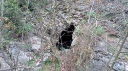
GROTTA PRESSO IL CASELLO DI NERVI
Synonyms
GROTTA DELL'OMETTO
Firstreference
LEO PAGANO
Regione
LIGURIA
Provincia
GE
Comune
GENOVA
Localita
CASELLO DI GENOVA NERVI
Areas
Geologicalformation
FAN FORMAZIONE DEL M. ANTOLA
Size
Lenght total
6
Lenght planimetric
3
Depth positive
5
Depth negative
1
Depth total
6
Entrance location
Latitude
44º 23' 48.8'' N
Longitude
9º 00' 54.8''
Coordinates type
GPS Geografiche WGS84
Original coordinates type
GPS Geografiche WGS84
Elevation
127
Archeological
No
Marine
No
Environmentalrisk
No
Destroyed
Partially
Practicability
FACILE
Associations
ISSEL
Description
La cavità alla base è ostruita da sassi e detriti, probabilmente è stata riempita durante i lavori autostradali. A pochi metri dalla grotta si apre un pozzetto verticale di 4 metri anch'esso ostruito da detriti. Pare che prima della chiusura fosse attraversata da un rigagnolo.
Itinerary
dal Casello di Genova Nervi raggiungere via Palmiro Togliatti fino al campo di calcio. La grotta è raggiungibile risalendo il bosco fino ad intercettare la vecchia strada utilizzata da Autostrade. La grotta si apre sul lato della strada stessa.
Authorphoto1
Alessandro Vernassa
Authordescription
Alessandro Vernassa
Authoritinerary
Alessandro Vernassa
Import rawdata
1{_"REGIONE":"LI","PROV":"GE","NUM":"1873","SPECIF":null,"DATAGG":null,"DRILEV":null,"NOME":"GROTTA PRESSO IL CASELLO DI NERVI","SINON":"GROTTA DELL'OMETTO","RAS":null,"COMUNE":"GENOVA","LOCAL":"CASELLO DI GENOVA NERVI","ACAR":null,"ACARCOD":"CG_GE1","FM":null,"FMCOD":"FAN","AGE":null,"SVILRE":"6","SVILPLAN":"3","ESTEN":null,"DPOS":"5","DNEG":"1","DTOT":"6","TC_01":"GPS Geografiche WGS84","latitude":"44\u00ba 23' 48.8'' N","longitude":"9\u00ba 00' 54.8''","DC_01":null,"SC_01":null,"AE_01":null,"QA_01":"127","QC_01":null,"VD_01":null,"IDRO":null,"RILEVATORI":"LEO PAGANO","GRADORIL":null,"GRUPPI":"ISSEL\r\n","NOTE":null,"DATARIL":null,"NOTE2":null,"RCS":null,"ITINERARIO":"dal Casello di Genova Nervi raggiungere via Palmiro Togliatti fino al campo di calcio. La grotta \u00e8 raggiungibile risalendo il bosco fino ad intercettare la vecchia strada utilizzata da Autostrade. La grotta si apre sul lato della strada stessa.","DESCRIZIONE":"La cavit\u00e0 alla base \u00e8 ostruita da sassi e detriti, probabilmente \u00e8 stata riempita durante i lavori autostradali. A pochi metri dalla grotta si apre un pozzetto verticale di 4 metri anch'esso ostruito da detriti. Pare che prima della chiusura fosse attraversata da un rigagnolo.","PERCORRIBILITA":"FACILE","recordinsert":"2015-01-17 12:12:24","recordupdate":"2019-03-21 11:47:52","username":"alessandrovernassa","userupdate":"alessandrovernassa","marina":"N","archeologica":"N","rischioambientale":"N","chiusa":"N","distrutta":"P","data_verifica":null,"hidden":"0","photo1":"casello_nervi_ingresso.jpeg","authorphoto1":"Alessandro Vernassa","authorDESCRIZIONE":"Alessandro Vernassa","authorITINERARIO":"Alessandro Vernassa"}
Dati compilazione
Recordinsert
17/01/2015
Username
alessandrovernassa
Userupdate
alessandrovernassa
Recordupdate
21/03/2019
Coordinate WGS84 (Lon,Lat):
Coordinate WGS84 (Lon,Lat):
Coordinate WGS84 UTM (x,y,zone):
Genera scheda catastale
Download update form
